Ashburton, New Zealand
town in New Zealand's South Island
Ashburton (Māori: Hakatere) is a town in the Canterbury Region, on the east coast of the South Island of New Zealand[3] The town has a population of 20,800.[2]
Ashburton
Hakatere (Māori) | |
|---|---|
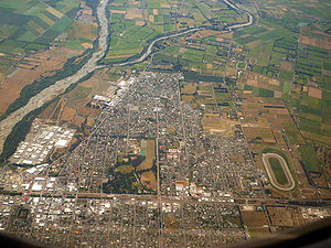
 Aerial view of Ashburton, looking west. The Ashburton River/Hakatere is visible at left. | |
| Nickname: Ashvegas | |
 Location of Ashburton | |
| Coordinates: 43°54′20″S 171°44′44″E / 43.90556°S 171.74556°E | |
| Country | New Zealand |
| Region | Canterbury |
| District | Ashburton District Council |
| Ward | Ashburton |
| Electorates |
|
| Government | |
| • Territorial authority | Ashburton District Council |
| • Regional council | Environment Canterbury |
| • Mayor of Ashburton | Neil Brown |
| • Rangitata MP | James Meager |
| • Te Tai Tonga MP | Tākuta Ferris |
| Area | |
| • Territorial | 39.99 km2 (15.44 sq mi) |
| Population (June 2023)[2] | |
| • Territorial | 20,800 |
| • Density | 520/km2 (1,300/sq mi) |
| Demonym | Ashburtonian |
| Time zone | UTC+12 (NZST) |
| • Summer (DST) | UTC+13 (NZDT) |
| Postcode(s) | |
| Postcode(s) | 7700 |
| Area code | 03 |
| Local iwi | Ngāi Tahu |
| Website | Ashburton District Council |
History
changeThe town was established in 1858, .[4] The Canterbury government gave Ashburton £20,000 to build roads in the district in 1873 and a railway in 1874.[4] The Presbyterian church was established in 1876 and the Catholic church in 1882.[5]
Ashburton was listed as a borough in 1878.[5] Ashburton was used as a training base for the Royal New Zealand Air Force during World War 2.[6]
References
change- ↑ Cite error: The named reference
Areawas used but no text was provided for refs named (see the help page). - ↑ 2.0 2.1 "Subnational population estimates (RC, SA2), by age and sex, at 30 June 1996-2023 (2023 boundaries)". Statistics New Zealand. Retrieved 25 October 2023. (regional councils); "Subnational population estimates (TA, SA2), by age and sex, at 30 June 1996-2023 (2023 boundaries)". Statistics New Zealand. Retrieved 25 October 2023. (territorial authorities); "Subnational population estimates (urban rural), by age and sex, at 30 June 1996-2023 (2023 boundaries)". Statistics New Zealand. Retrieved 25 October 2023. (urban areas)
- ↑ O'Neill, Peter (15 June 2011). "Editorial comment". Ashburton Guardian. Archived from the original on 3 April 2012.
We are close enough to be considered a satellite town.
- ↑ 4.0 4.1 "[Ashburton] | NZETC". nzetc.victoria.ac.nz. Archived from the original on 20 February 2021. Retrieved 26 June 2021.
- ↑ 5.0 5.1 "[Ashburton] | NZETC". nzetc.victoria.ac.nz. Archived from the original on 20 February 2021. Retrieved 12 June 2021.
- ↑ "Ashburton, Mid Canterbury has a strong aviation history, being a training base in World War 2. There were 50 Tiger Moths based there. The Ashburton Aviation Museum is well worth a visit". midcanterburynz.com. Archived from the original on 11 June 2021. Retrieved 19 June 2021.
Sources
change- Reed, A. W. (2002). The Reed Dictionary of New Zealand Place Names. Auckland: Reed Books. ISBN 0-7900-0761-4.
Other websites
changeWikimedia Commons has media related to Ashburton, New Zealand.