File:Australia Victoria Benalla RC location map.svg

Size of this PNG preview of this SVG file: 338 × 600 pixels. Other resolutions: 135 × 240 pixels | 270 × 480 pixels | 432 × 768 pixels | 577 × 1,024 pixels | 1,154 × 2,048 pixels | 533 × 946 pixels.
Original file (SVG file, nominally 533 × 946 pixels, file size: 666 KB)
| This is a file from the Wikimedia Commons. Information from its description page there is shown below. Commons is a freely licensed media file repository. You can help. |
| Description |
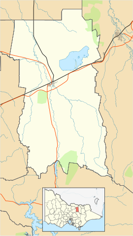
English: Blank map of the w:Rural City of Benalla, Victoria, Australia, with the following information shown:
Geographic limits:
|
||
| Source | Own work + VicMap Lite | ||
| Author | Cassowary |

File history
Click on a date/time to view the file as it appeared at that time.
| Date/Time | Thumbnail | Dimensions | User | Comment | |
|---|---|---|---|---|---|
| current | 14:30, 16 February 2011 | | 533 × 946 (666 KB) | Cassowary | {{Information |Description ={{en|1=Blank map of the w:Rural City of Benalla, Victoria, Australia, with the following information shown: * LGA boundaries * Coastline, lakes and rivers * Roads and railways * Urban areas * Parks Geographic limits: * |
File usage
The following 3 pages use this file:
Global file usage
The following other wikis use this file:
- Usage on ar.wiki.x.io
- Usage on ceb.wiki.x.io
- Usage on ckb.wiki.x.io
- Usage on en.wiki.x.io
- Benalla
- Rural City of Benalla
- Baddaginnie, Victoria
- Tatong
- Tolmie, Victoria
- Devenish, Victoria
- Goorambat, Victoria
- Template:Towns in the Rural City of Benalla
- Swanpool, Victoria
- Thoona
- Major Plains, Victoria
- Winton, Victoria
- Molyullah, Victoria
- Warrenbayne
- Template:Infobox Australian place/testcases
- Module:Location map/data/Australia Victoria Rural City of Benalla/doc
- Broken Creek, Victoria
- Goomalibee
- Module:Location map/data/Australia Victoria Rural City of Benalla
- User:Viatori/sandbox
- User:ThylacineHunter/LGA
- Draft:Sandbox/Innesw/Infobox Australian place/testcases
- Template:Sandbox/Innesw/Infobox Australian place-upgrade/testcases
- Usage on fa.wiki.x.io
- Usage on kn.wiki.x.io
- Usage on si.wiki.x.io
- Usage on tr.wiki.x.io
- Usage on ur.wiki.x.io
- Usage on uz.wiki.x.io
- Usage on war.wiki.x.io