File:Kurdistan governorates 2012.png

Size of this preview: 643 × 600 pixels. Other resolutions: 257 × 240 pixels | 515 × 480 pixels | 1,000 × 933 pixels.
Original file (1,000 × 933 pixels, file size: 53 KB, MIME type: image/png)
| This is a file from the Wikimedia Commons. Information from its description page there is shown below. Commons is a freely licensed media file repository. You can help. |
Summary
| Description |
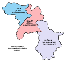
English: Map showing the governorates of Kurdistan Region in Iraq (in 2012). |
| Date | |
| Source | Own work |
| Author | PANONIAN |
Licensing
I, the copyright holder of this work, hereby publish it under the following license:
| This file is made available under the Creative Commons CC0 1.0 Universal Public Domain Dedication. | |
| The person who associated a work with this deed has dedicated the work to the public domain by waiving all of their rights to the work worldwide under copyright law, including all related and neighboring rights, to the extent allowed by law. You can copy, modify, distribute and perform the work, even for commercial purposes, all without asking permission.
|
Refences
Borders of Kurdistan Region governorates are made in accordance with these maps provided by the Kurdistan Region Statistics Office:
- http://www.krso.net/en/maps
- http://www.krso.net/documents/78/SubDistricts%20of%20the%20Governorates%20of%20Kurdistan%20Region.jpg
- http://www.krso.net/documents/38/Districts%20of%20the%20Governorates%20of%20Kurdistan%20Region.jpg
- http://www.krso.net/pdf/KRG-map-english.jpg
File history
Click on a date/time to view the file as it appeared at that time.
| Date/Time | Thumbnail | Dimensions | User | Comment | |
|---|---|---|---|---|---|
| current | 10:24, 6 September 2014 | | 1,000 × 933 (53 KB) | PANONIAN | {{Information |Description ={{en|1=Map showing the governorates of Kurdistan Region in Iraq (in 2012).}} |Source ={{own}} |Author =PANONIAN |Date =2014 |Permission = |other_versions = }} |
File usage
The following 2 pages use this file:
Global file usage
The following other wikis use this file:
- Usage on arc.wiki.x.io
- Usage on arz.wiki.x.io
- Usage on be.wiki.x.io
- Usage on bg.wiki.x.io
- Usage on bn.wiki.x.io
- Usage on ca.wiki.x.io
- Usage on ckb.wiki.x.io
- Usage on cs.wiki.x.io
- Usage on cy.wiki.x.io
- Usage on da.wiki.x.io
- Usage on eo.wiki.x.io
- Usage on es.wiki.x.io
- Usage on et.wiki.x.io
- Usage on fr.wiki.x.io
- Usage on hi.wiki.x.io
- Usage on hu.wiki.x.io
- Usage on id.wiki.x.io
- Usage on it.wiki.x.io
- Usage on ja.wiki.x.io
- Usage on kk.wiki.x.io
- Usage on ko.wiki.x.io
- Usage on ku.wiki.x.io
View more global usage of this file.