File:Map operation husky landing.jpg
Size of this preview: 800 × 576 pixels. Other resolutions: 320 × 230 pixels | 640 × 461 pixels | 806 × 580 pixels.
Original file (806 × 580 pixels, file size: 184 KB, MIME type: image/jpeg)
| This is a file from the Wikimedia Commons. Information from its description page there is shown below. Commons is a freely licensed media file repository. You can help. |

|
This file has been superseded by Map Operation Husky and Axis Dispositions.svg. It is recommended to use the other file. Please note that deleting superseded images requires consent.
|

|
- Source: http://www.history.army.mil/brochures/72-16/map1.JPG archive copy at the Wayback Machine
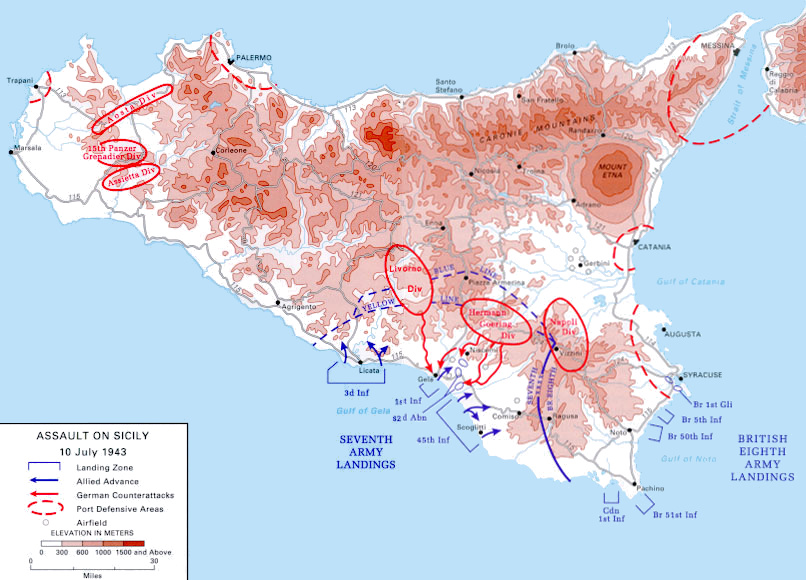
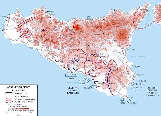
- Description: This is a map of the Allied army amphibious landing in Sicily, July 10th, 1943, as part of Operation Husky. It shows the deployments of the landing forces and the German and Italian formations defending the island.
- Reference: Army brochure — Sicily 1943
- Width: 806 pixels
- Height: 580 pixels
| This image is in the public domain because it contains materials that originally came from the United States Army Center of Military History, subject to the following qualification.
Note: The images of all badges, insignia, decorations and medals on the "CMH Online" web site are produced by the United States Army Institute of Heraldry and protected by Title 18, United States Code, Section 704 and the Code of Federal Regulations (32 CFR, Part 507). Permission to use these images for commercial purposes must be obtained from The Institute of Heraldry prior to their use. |

|
File history
Click on a date/time to view the file as it appeared at that time.
| Date/Time | Thumbnail | Dimensions | User | Comment | |
|---|---|---|---|---|---|
| current | 16:51, 12 May 2017 | | 806 × 580 (184 KB) | Hohum | Cleanup |
| 10:28, 6 April 2005 |  | 806 × 580 (134 KB) | Greuff~commonswiki | *'''Source:''' http://www.army.mil/cmh-pg/brochures/72-16/map1.JPG *'''Description:''' This is a map of the Allied army amphibious landing in Sicily, July 10th, 1943, as part of Operation Husky. It shows the deployments of the landing forc |
File usage
The following page uses this file:
Global file usage
The following other wikis use this file:
- Usage on ar.wiki.x.io
- Usage on ast.wiki.x.io
- Usage on az.wiki.x.io
- Usage on bg.wiki.x.io
- Usage on ca.wiki.x.io
- Usage on ceb.wiki.x.io
- Usage on cs.wiki.x.io
- Usage on da.wiki.x.io
- Usage on de.wiki.x.io
- Usage on el.wiki.x.io
- Usage on en.wiki.x.io
- Usage on es.wiki.x.io
- Usage on eu.wiki.x.io
- Usage on fi.wiki.x.io
- Usage on fr.wiki.x.io
- Usage on he.wiki.x.io
- Usage on hr.wiki.x.io
- Usage on hu.wiki.x.io
- Usage on hy.wiki.x.io
- Usage on io.wiki.x.io
- Usage on it.wiki.x.io
- Usage on ja.wiki.x.io
- Usage on ka.wiki.x.io
- Usage on lt.wiki.x.io
- Usage on lv.wiki.x.io
View more global usage of this file.