Size of this preview: 800 × 519 pixels. Other resolutions: 320 × 207 pixels | 640 × 415 pixels | 839 × 544 pixels.
Original file (839 × 544 pixels, file size: 28 KB, MIME type: image/gif)
| This is a file from the Wikimedia Commons. Information from its description page there is shown below. Commons is a freely licensed media file repository. You can help. |
Summary
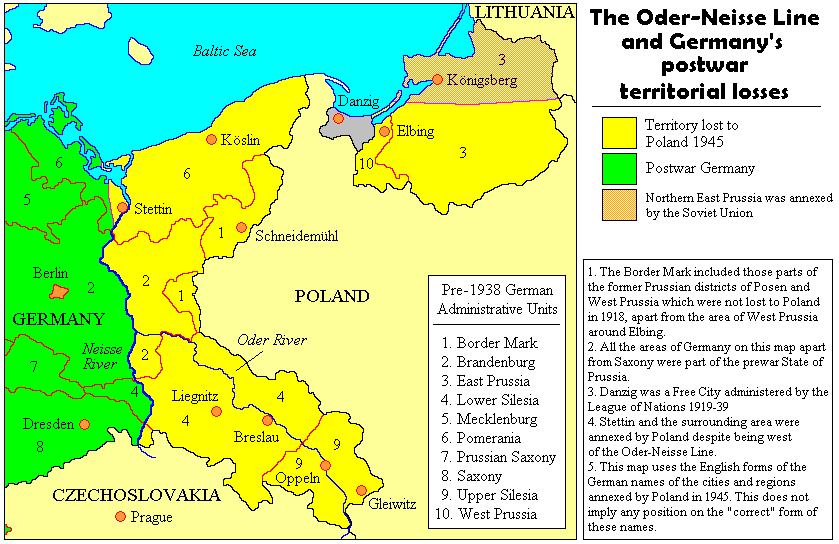
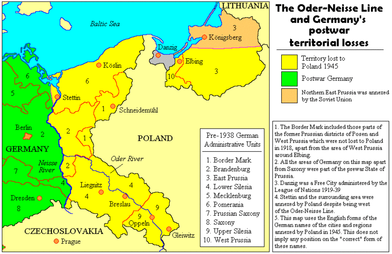
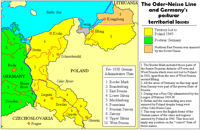
The map shows the Oder-Neisse-line, that is the border between Germany and Poland after world war 2. The map is made by user Adam Carr on english Wikipedia, [1], and he has given permission to have it uploaded on Commons.
![[1]](https://en.wiki.x.io/wiki/Image:Oder-neisse.gif)
Licensing
| This file is licensed under the Creative Commons Attribution-Share Alike 3.0 Unported license. Subject to disclaimers. | ||
| ||
| This licensing tag was added to this file as part of the GFDL licensing update. |

|
Permission is granted to copy, distribute and/or modify this document under the terms of the GNU Free Documentation License, Version 1.2 or any later version published by the Free Software Foundation; with no Invariant Sections, no Front-Cover Texts, and no Back-Cover Texts. A copy of the license is included in the section entitled GNU Free Documentation License. Subject to disclaimers. |
File history
Click on a date/time to view the file as it appeared at that time.
| Date/Time | Thumbnail | Dimensions | User | Comment | |
|---|---|---|---|---|---|
| current | 15:33, 27 October 2011 | | 839 × 544 (28 KB) | Ras67 | cropped |
| 13:30, 8 January 2011 |  | 847 × 552 (29 KB) | Unzatrapis | corrected prussian border; different color of East Prussia's part that was not lost to Poland; corretions on map legend: "pre-1945" -> "pre-1938"; "arround Elbling" -> "arround Elbing". | |
| 11:33, 24 July 2009 |  | 847 × 552 (28 KB) | Botaurus | Elbling ---> Elbing | |
| 15:05, 6 October 2006 |  | 847 × 552 (28 KB) | Ulflarsen | The map shows the Oder-Neisse-line, that is the border between Germany and Poland after world war 2. The map is made by user Adam Carr on english Wikipedia, [http://en.wiki.x.io/wiki/Image:Oder-neisse.gif], and he has given permission to have it uploa |
File usage
The following page uses this file:
Global file usage
The following other wikis use this file:
- Usage on azb.wiki.x.io
- Usage on be.wiki.x.io
- Usage on cs.wiki.x.io
- Usage on da.wiki.x.io
- Usage on de.wiki.x.io
- Usage on en.wiki.x.io
- Usage on fr.wiki.x.io
- Usage on it.wiki.x.io
- Usage on no.wiki.x.io
- Usage on pl.wiki.x.io
- Usage on ro.wiki.x.io
- Usage on ru.wiki.x.io
- Usage on zh.wiki.x.io