File:Reynolds's Political Map of the United States 1856.jpg

Size of this preview: 661 × 600 pixels. Other resolutions: 265 × 240 pixels | 529 × 480 pixels | 846 × 768 pixels | 1,128 × 1,024 pixels | 2,257 × 2,048 pixels | 7,813 × 7,090 pixels.
Original file (7,813 × 7,090 pixels, file size: 19.76 MB, MIME type: image/jpeg)
| This is a file from the Wikimedia Commons. Information from its description page there is shown below. Commons is a freely licensed media file repository. You can help. |
| Warning | The original file is very high-resolution. It might not load properly or could cause your browser to freeze when opened at full size. |
|---|
Summary
| Description |
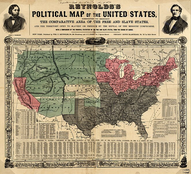
English: US map 1856 shows free and slave states and populations; this is "Reynolds's Political Map of the United States" (1856) from Library of Congress collection[1] |
| Date | circa 1856 |
| Source | "Reynolds's Political Map of the United States" (1856) from the Library of Congress Geography and Map Division |
| Author | New York: Wm. C. Reynolds and J. C. Jones |
| Permission (Reusing this file) |
This image is in the public domain due to its age. |
Licensing
|
This work is in the public domain in its country of origin and other countries and areas where the copyright term is the author's life plus 70 years or fewer. | |
| This file has been identified as being free of known restrictions under copyright law, including all related and neighboring rights. | |
Wikipedia upload log
Also copied to en:Wikipedia earlier than Commons upload; a Wikipedia description page is/was here. All following user names refer to en.wikipedia.
- 2006-02-25 07:24 Rjensen 2000×1736×??? (725895 bytes) US map 1854 shows free and slave states and sata
File history
Click on a date/time to view the file as it appeared at that time.
| Date/Time | Thumbnail | Dimensions | User | Comment | |
|---|---|---|---|---|---|
| current | 18:29, 16 August 2023 | | 7,813 × 7,090 (19.76 MB) | Jengod | Autotune so brighter and easier to read |
| 07:28, 22 April 2016 |  | 7,813 × 7,090 (35.27 MB) | Khamar | Original improved in Adobe Photoshop by removing white strip through center where left and right sides of map join, removing some dark and white stripes from image, and nudging some of the text and lines back into alignment preserving as much of the ma... | |
| 01:40, 17 December 2012 |  | 7,828 × 7,090 (16.56 MB) | T3hBra1nWa5her | Higher resolution version from the [http://memory.loc.gov/cgi-bin/query/h?ammem/gmd:@field(NUMBER+@band(g3701e+ct000604)) Library of Congress Geography and Map Division Washington]. | |
| 13:15, 1 August 2008 |  | 2,000 × 1,736 (709 KB) | Bdamokos | {{Information |Description={{en|US map 1856 shows free and slave states and populations; this is "Reynolds's Political Map of the United States" (1856) from Library of Congress collection[http://lcweb2.loc.gov/ammem/aaohtml/exhibit/aopart3b.html] [[:en |
File usage
The following 3 pages use this file:
Global file usage
The following other wikis use this file:
- Usage on ar.wiki.x.io
- Usage on ca.wiki.x.io
- Usage on de.wiki.x.io
- Usage on en.wiki.x.io
- Usage on en.wikiquote.org
- Usage on es.wiki.x.io
- Usage on fa.wiki.x.io
- Usage on fi.wiki.x.io
- Usage on fr.wiki.x.io
- Usage on he.wiki.x.io
- Usage on hu.wiki.x.io
- Usage on id.wiki.x.io
- Usage on it.wiki.x.io
- Usage on ja.wiki.x.io
- Usage on ko.wiki.x.io
- Usage on no.wiki.x.io
- Usage on pl.wiki.x.io
- Usage on pt.wiki.x.io
- Usage on ro.wiki.x.io
- Usage on ru.wiki.x.io
- Usage on sh.wiki.x.io
View more global usage of this file.