Karaganda
Karaganda or Qaraghandy is a city in Kazakhstan, the center of the Karaganda Region. It has a population of 515,819 people (as of 2023).[1]
Karaganda
Қарағанды Qarağandy | |
|---|---|
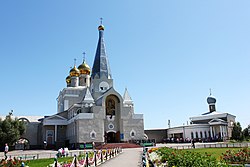
 Karaganda Catholic Cathedral | |
| Coordinates: 49°48′10″N 73°06′20″E / 49.80278°N 73.10556°E | |
| Country | |
| Region | Qaraghandy |
| Founded | 1931 |
| Incorporated (city) | February 10, 1934 |
| Government | |
| • Akim (mayor) | Meiram Kozhukhov (Kazakh: Мейрам Кожухов)[2] |
| Area | |
| • City | 497.8 km2 (192.2 sq mi) |
| Population (2023) | |
| • City | 515,625[1] |
| • Rank | 5th |
| • Urban | 515,819 |
| Time zone | GMT+6 |
| • Summer (DST) | UTC+6 (UTC+6) |
| Postal code | 100000 - 100030 |
| Area code | +7 7212 |
| Website | www |
Karaganda is now one of Kazakhstan's biggest centers for industry, economy, science, and culture.
History
changeThe place was founded in 1856 as a copper mining village. In the 1930s, construction of the city of Karaganda started due to the development of coal nearby. On February 10, 1934, Karaganda became a city.[3]
In 1984, in the year when Karaganda became 50 years old, the government awarded the city the Order of the Red Banner of Labour (en).
Geography
changeKaraganda, like all of Central Kazakhstan, has a continental climate. This means that the winters here are very cold and the summers are very hot. The city's average annual temperature is 3.6 °C (38.4 °F).
| Climate data for Karaganda | |||||||||||||
|---|---|---|---|---|---|---|---|---|---|---|---|---|---|
| Month | Jan | Feb | Mar | Apr | May | Jun | Jul | Aug | Sep | Oct | Nov | Dec | Year |
| Record high °C (°F) | 6.2 (43.2) |
7.0 (44.6) |
22.3 (72.1) |
30.8 (87.4) |
35.6 (96.1) |
39.1 (102.4) |
39.6 (103.3) |
40.2 (104.4) |
37.4 (99.3) |
27.6 (81.7) |
18.4 (65.1) |
11.5 (52.7) |
40.2 (104.4) |
| Average high °C (°F) | −9.2 (15.4) |
−7.6 (18.3) |
−0.6 (30.9) |
12.9 (55.2) |
20.4 (68.7) |
25.4 (77.7) |
26.4 (79.5) |
25.5 (77.9) |
19.0 (66.2) |
10.9 (51.6) |
−0.6 (30.9) |
−7.1 (19.2) |
9.6 (49.3) |
| Daily mean °C (°F) | −13.4 (7.9) |
−12.5 (9.5) |
−5.4 (22.3) |
6.4 (43.5) |
13.5 (56.3) |
18.8 (65.8) |
20.0 (68.0) |
18.6 (65.5) |
12.1 (53.8) |
4.8 (40.6) |
−5.0 (23.0) |
−11.2 (11.8) |
3.9 (39.0) |
| Average low °C (°F) | −17.7 (0.1) |
−17.2 (1.0) |
−9.8 (14.4) |
0.8 (33.4) |
6.9 (44.4) |
12.3 (54.1) |
13.9 (57.0) |
12.1 (53.8) |
5.9 (42.6) |
−0.1 (31.8) |
−8.7 (16.3) |
−15.3 (4.5) |
−1.4 (29.5) |
| Record low °C (°F) | −41.7 (−43.1) |
−41.0 (−41.8) |
−34.7 (−30.5) |
−23.9 (−11.0) |
−9.5 (14.9) |
−2.3 (27.9) |
3.2 (37.8) |
−0.8 (30.6) |
−8.4 (16.9) |
−19.3 (−2.7) |
−38 (−36) |
−42.9 (−45.2) |
−42.9 (−45.2) |
| Average precipitation mm (inches) | 25 (1.0) |
24 (0.9) |
27 (1.1) |
30 (1.2) |
37 (1.5) |
43 (1.7) |
52 (2.0) |
29 (1.1) |
21 (0.8) |
30 (1.2) |
33 (1.3) |
31 (1.2) |
382 (15.0) |
| Average rainy days | 1 | 1 | 4 | 9 | 14 | 12 | 14 | 10 | 9 | 9 | 6 | 2 | 91 |
| Average snowy days | 20 | 19 | 15 | 6 | 1 | 0 | 0 | 0 | 1 | 7 | 15 | 19 | 103 |
| Average relative humidity (%) | 79 | 78 | 78 | 61 | 54 | 50 | 55 | 52 | 53 | 66 | 77 | 78 | 65 |
| Mean monthly sunshine hours | 106 | 142 | 189 | 231 | 297 | 335 | 330 | 303 | 247 | 141 | 108 | 99 | 2,528 |
| Source 1: Pogoda.ru.net[4] | |||||||||||||
| Source 2: NOAA (sun, 1961–1990)[5] | |||||||||||||
References
change- ↑ 1.0 1.1 "Population of the Republic of Kazakhstan by gender and type of area (as of 2023-01-01)". QazStat. 2023-01-01. Archived from the original on 2023-03-05.
- ↑ "Назначен аким Караганды" (in Russian). 2023-01-18.
- ↑ "Karaganda is a city of miners". Qazaqstan Tarihy. 2016-11-27. Retrieved 2023-11-14.
- ↑ "Weather and Climate - The Climate of Karaganda" (in Russian). Weather and Climate (Погода и климат). Archived from the original on 25 November 2016. Retrieved 3 January 2022.
- ↑ "Karaganda Climate Normals 1961-1990". National Oceanic and Atmospheric Administration. Retrieved 25 November 2016.

