Province of Rovigo
The Province of Rovigo (Italian: Provincia di Rovigo) is a province in the Veneto region of Italy. Its capital is the city of Rovigo.
Province of Rovigo | |
|---|---|
 | |
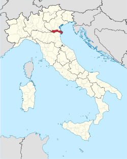
 Map with the province of Rovigo, in red, in Italy | |
| Coordinates: 45°04′N 11°47′E / 45.067°N 11.783°E | |
| Country | Italy |
| Region | Veneto |
| Capital | Rovigo |
| Comuni | 50 |
| Government | |
| • President | Marco Trombini |
| Area | |
| • Total | 1,819.35 km2 (702.45 sq mi) |
| Population (1 January 2016)[2] | |
| • Total | 240,540 |
| • Density | 130/km2 (340/sq mi) |
| Time zone | UTC+1 (CET) |
| • Summer (DST) | UTC+2 (CEST) |
| Postal code | 45100, 45010-45039 |
| Telephone prefix | 0425, 0426 |
| ISO 3166 code | IT-RO |
| Vehicle registration | RO |
| ISTAT | 029 |
| Website | Official website |
Geography
changeThe province of Rovigo has an area of 1,819.35 km2 (702.45 sq mi) and is the most southern of the provinces of the Veneto region, and its territory is almost flat, without mountains. The highest point of the province is in the Bergantino comune, to the west of the province; it is only 15 m (49 ft) high.[3]
The province is rich in water, with the presence of the two longest rivers of Italy: the Po and the Adige rivers. Both flow from west to east and into the Adriatic Sea and most of the territory of the province is between these two rivers: the Adige in the north of the province and the Po in the south of it.
The province of Rovigo borders to the northwest with the Province of Verona. The Province of Padua and the Metropolitan City of Venice are to the north. The Province of Mantua (in the Lombardy region) is to the west. The Province of Ferrara (in the Emilia-Romagna region) is to the south. The Adriatic Sea is to the east.
Population
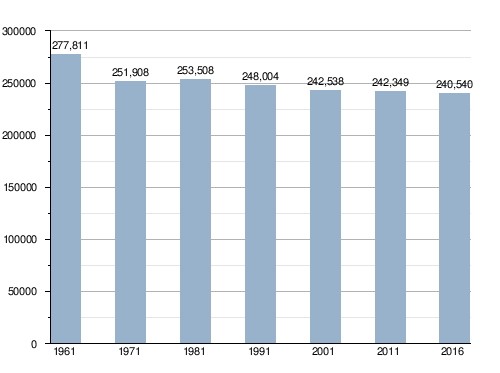
changeAs of 1 January 2016[update], there are 240,540 persons living in the province,[2] for a population density of 132.2 inhabitants/km².
Evolution of the population in the Rovigo province

Municipalities
changeThere are 50 municipalities (or comuni) in the province; they are:
- Adria
- Ariano nel Polesine
- Arquà Polesine
- Badia Polesine
- Bagnolo di Po
- Bergantino
- Bosaro
- Calto
- Canaro
- Canda
- Castelguglielmo
- Castelmassa
- Castelnovo Bariano
- Ceneselli
- Ceregnano
- Corbola
- Costa di Rovigo
- Crespino
- Ficarolo
- Fiesso Umbertiano
- Frassinelle Polesine
- Fratta Polesine
- Gaiba
- Gavello
- Giacciano con Baruchella
- Guarda Veneta
- Lendinara
- Loreo
- Lusia
- Melara
- Occhiobello
- Papozze
- Pettorazza Grimani
- Pincara
- Polesella
- Pontecchio Polesine
- Porto Tolle
- Porto Viro
- Rosolina
- Rovigo
- Salara
- San Bellino
- San Martino di Venezze
- Stienta
- Taglio di Po
- Trecenta
- Villadose
- Villamarzana
- Villanova del Ghebbo
- Villanova Marchesana
Largest municipalities
changeThe following shows the 10 comuni with the population,[2] and the area and altitude.[4]
| No. | Comune | Population (2016) |
Area (km²) |
Density | Altitude (m) |
|---|---|---|---|---|---|
| 1 | Rovigo | 51,867 | 108.81 | 476.7 | 7 |
| 2 | Adria | 19,746 | 113.39 | 174.1 | 4 |
| 3 | Porto Viro | 14,494 | 133.77 | 108.4 | 2 |
| 4 | Occhiobello | 11,979 | 32.33 | 370.5 | 8 |
| 5 | Lendinara | 11,873 | 55.06 | 215.6 | 9 |
| 6 | Badia Polesine | 10,509 | 44.53 | 236.0 | 11 |
| 7 | Porto Tolle | 9,826 | 256.88 | 38.3 | 1 |
| 8 | Taglio di Po | 8,356 | 78.68 | 106.2 | 0 |
| 9 | Rosolina | 6,483 | 74.69 | 86.8 | 1 |
| 10 | Villadose | 5,099 | 32.07 | 159.0 | 3 |
Gallery
change-
Aerial view of Melara (with Po river).
-
The Adige river near Badia Polesine.
-
Piazza Riconoscenza, Rovigo.
-
Piazza Garibaldi, Adria.
References
change- ↑ "Provincia di Rovigo" (in Italian). Tuttitalia.it. Retrieved 25 June 2017.
- ↑ 2.0 2.1 2.2 "Statistiche demografiche ISTAT" (in Italian). Demo.istat.it. Archived from the original on 26 June 2017. Retrieved 6 April 2017.
- ↑ "Bergantino, Italy". Peakbagger.com. Retrieved 25 June 2017.
- ↑ "Comuni in provincia di Rovigo per popolazione" (in Italian). Tuttitalia.it. Retrieved 26 June 2017.
Other websites
change- Provincia di Rovigo Official site (in Italian)

