Queen Charlotte Strait
Queen Charlotte Strait is a strait between Vancouver Island and the rest of British Columbia in Canada. It connects Queen Charlotte Sound to Johnstone Strait and Discovery Passage. It also goes through them to connect Queen Charlotte Sound to the Strait of Georgia and Puget Sound. It is part of the Inside Passage, which goes from Washington to Alaska.
| Queen Charlotte Strait | |
|---|---|
| French: Détroit de la Reine-Charlotte | |
 A pilot boat plies Queen Charlotte Strait near Port Hardy | |
 Queen Charlotte Strait is located southeast of Queen Charlotte Sound | |
| Location | British Columbia |
| Coordinates | 50°50′16″N 127°27′29″W / 50.83778°N 127.45806°W |
| Type | Strait |
| Ocean/sea sources | Pacific Ocean |
| Settlements | Alert Bay, Port Hardy, Port McNeill, Sointula |
Etymology
changeJames Strange named it Queen Charlotte Sound on August 5, 1786. He named it after Queen Charlotte. She was the wife of King George III.[1] Queen Charlotte Strait was called Queen Charlotte Sound until 1920. In 1920, the BCGNIS and Hydrographic Service said that Queen Charlotte Sound and Queen Charlotte Strait were not the same.[2]
Geography
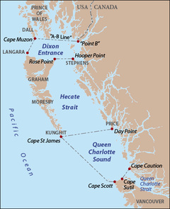
changeAccording to the BC Geographical Names, the northern border of Queen Charlotte Strait is a line across Cape Sutil, at the north end of Vancouver Island, to Cape Caution on the mainland. The southern border of Queen Charlotte Strait is a group of narrow channels north and east of Malcolm Island.[2]
References
change- ↑ Pethick, Derek (1976). First Approaches to the Northwest Coast. Vancouver: J.J. Douglas. pp. 81, 88. ISBN 0-88894-056-4.
- ↑ 2.0 2.1 "Queen Charlotte Strait". BC Geographical Names.
