Smoky Hill River
river in Colorado and Kansas, United States
The Smoky Hill River is a 575-mile (925 km)[4] river in the central Great Plains of North America. It goes through the U.S. states of Colorado and Kansas.[5]
| Smoky Hill River Aahkawirarahkata, Chetolah, Oke-see-sebo,[1] River of the Padoucas[2] | |
|---|---|
 Smoky Hill River near Assaria, Kansas | |
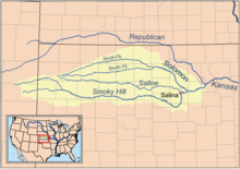
 Map of the Smoky Hill drainage basin | |
| Location | |
| Country | United States |
| State | Colorado, Kansas |
| Physical characteristics | |
| Source | |
| - location | Cheyenne County, Colorado |
| - coordinates | 38°57′01″N 102°34′49″W / 38.95028°N 102.58028°W[1] |
| - elevation | 4,640 ft (1,410 m) |
| Mouth | Kansas River |
| - location | Junction City, Kansas |
| - coordinates | 39°03′36″N 98°46′04″W / 39.06000°N 98.76778°W[1] |
| - elevation | 1,040 ft (320 m) |
| Length | 575 mi (925 km) |
| Basin size | 19,260 sq mi (49,900 km2) |
| Discharge | |
| - location | USGS 06877600 at Enterprise, KS[3] |
| - average | 1,540 cu ft/s (44 m3/s) |
| - minimum | 38 cu ft/s (1.1 m3/s) |
| - maximum | 207,000 cu ft/s (5,900 m3/s) |
| Basin features | |
| Tributaries | |
| - left | North Fork Smoky Hill River, Big Creek, Saline River, Solomon River |
| - right | Ladder Creek |
| Watersheds | Smoky Hill-Kansas-Missouri-Mississippi |
Name
changeThe river gets its name from the Smoky Hills area in the Great Plains.[2]
References
change- ↑ 1.0 1.1 1.2 U.S. Geological Survey Geographic Names Information System: Smoky Hill River
- ↑ 2.0 2.1 Root, George A. (February 1935). "Ferries in Kansas, Part VI -- Smoky Hill River". Kansas Historical Quarterly. 4 (1): 3–22.
- ↑ "Water resources data for the United States, Water Year 2009; gage 06877600, Smoky Hill River at Enterprise, KS" (PDF). USGS. Retrieved 1 August 2010.
- ↑ "National Hydrography Dataset". United States Geological Survey. Retrieved 14 June 2011.
- ↑ Smoky Hill River. (2009). In Encyclopædia Britannica. Retrieved July 22, 2009, from Encyclopædia Britannica Online: http://www.britannica.com/EBchecked/topic/550068/Smoky-Hill-River