Tirschenreuth
municipality of Germany
Tirschenreuth (Northern Bavarian: Dirschnrad, Diascharad) is the capital city of the district of Tirschenreuth. It is in the northeast of Bavaria, close to the Czech-Bavarian border.
Tirschenreuth | |
|---|---|
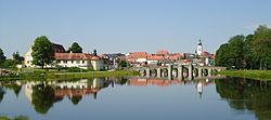
 Panorama of the Old Town of Tirschenreuth | |
| Coordinates: 49°53′N 12°20′E / 49.883°N 12.333°E | |
| Country | Germany |
| State | Bavaria |
| Admin. region | Upper Palatinate |
| District | Tirschenreuth |
| Government | |
| • Mayor (2020–26) | Franz Stahl[1] (CSU) |
| Area | |
| • Total | 66.54 km2 (25.69 sq mi) |
| Elevation | 504 m (1,654 ft) |
| Population (2022-12-31)[2] | |
| • Total | 8,655 |
| • Density | 130/km2 (340/sq mi) |
| Time zone | UTC+01:00 (CET) |
| • Summer (DST) | UTC+02:00 (CEST) |
| Postal codes | 95643 |
| Dialling codes | 09631 |
| Vehicle registration | TIR, KEM |
| Website | www.stadt-tirschenreuth.de |
Geography
changeTirschenreuth is in the north of Upper Palatinate administrative region, about 75 miles north of Regensburg and 35 miles east of Bayreuth.
Incorporations
changeThe following villages were incorporated in Tirschenreuth
- Großklenau
- Kleinklenau
- Brunn
- Gründlbach
- Haid
- Höfen
- Hohenwald
- Kleinkonreuth
- Lengenfeld
- Lohnsitz
- Marchaney
- Matzersreuth
- Mooslohe
- Pilmersreuth a. d. Straße
- Pilmersreuth a. Wald
- Rosall
- Rothenbürg
- Sägmühle
- Wondreb
- Wondrebhammer
- Zeidlweid
- Ziegelhütte
Twin towns and cities
changeTirschenreuth is twinned with:
- La Ville-du-Bois, France (2001)
- Planá, Czech Republic (2008)
- Lauf an der Pegnitz, Germany (2011)
- Santa Fe Springs, California, United States
References
change- ↑ Liste der ersten Bürgermeister/Oberbürgermeister in kreisangehörigen Gemeinden, Bayerisches Landesamt für Statistik, 15 July 2021.
- ↑ Genesis Online-Datenbank des Bayerischen Landesamtes für Statistik Tabelle 12411-003r Fortschreibung des Bevölkerungsstandes: Gemeinden, Stichtag (Einwohnerzahlen auf Grundlage des Zensus 2011) .


