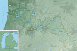
The Kalamazoo River is a river in the U.S. state of Michigan. The river is 130 miles (210 km) long.
| Kalamazoo River | |
|---|---|
 Map of the Kalamazoo River watershed | |
| Location | |
| Physical characteristics | |
| Source | |
| - location | South Branch : Near North Adams |
| - coordinates | 41°59′05″N 84°30′59″W / 41.98476°N 84.51633°W[5] North Branch: Near Farewell and Pine Hills lakes, Jackson County 42°05′47″N 84°28′38″W / 42.09643°N 84.47717°W[6] |
| Mouth | |
| - location | Lake Michigan |
| - coordinates | 42°40′36″N 86°12′55″W / 42.67669°N 86.21531°W[7] |
| Length | 130 miles (210 km) |
| Basin size | 5,230 km2 (2,020 sq mi) |
| Discharge | |
| - average | Marshall: 9.1 m3/s (320 cu ft/s)[1] Battle Creek: 19.4 m3/s (690 cu ft/s)[2] Comstock: 26.5 m3/s (940 cu ft/s)[2] Allegan : 45.8 m3/s (1,620 cu ft/s)[3] New Richmond: 52.8 m3/s (1,860 cu ft/s)[4] |
References
change- ↑ Mean of the yearly mean streamflows recorded by the USGS for the period 2002-2006.
- ↑ 2.0 2.1 Mean of the yearly mean streamflows recorded by the USGS for the period 2000-2006.
- ↑ Mean of the yearly mean streamflows recorded by the USGS for the period 2001-2005.
- ↑ Mean of the yearly mean streamflows recorded by the USGS for the period 2003-2006.
- ↑ "South Branch Kalamazoo River". Geographic Names Information System. United States Geological Survey.
- ↑ "North Branch Kalamazoo River". Geographic Names Information System. United States Geological Survey.
- ↑ "Kalamazoo River". Geographic Names Information System. United States Geological Survey.