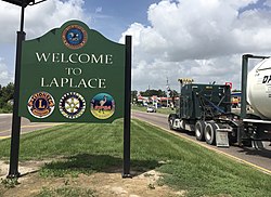
LaPlace, Louisiana
unincorporated suburban community and census-designated place in St. John the Baptist Parish, Louisiana, United States
LaPlace (/ləˈplɑːs/ lə-PLAHSS) is a census-designated place (CDP) in St. John the Baptist Parish, Louisiana, United States. It is near the east bank of the Mississippi River.[3] The population was 28,841 at the 2020 census.[2]
LaPlace, Louisiana | |
|---|---|
 U.S. Highway 61 (Airline Highway) at U.S. Highway 51 intersection in LaPlace | |
| Coordinates: 30°04′30″N 90°29′06″W / 30.07500°N 90.48500°W | |
| Country | United States |
| State | Louisiana |
| Parish | St. John the Baptist |
| Area | |
| • Total | 22.05 sq mi (57.11 km2) |
| • Land | 20.89 sq mi (54.12 km2) |
| • Water | 1.16 sq mi (2.99 km2) |
| Elevation | 10 ft (3 m) |
| Population | |
| • Total | 28,841 |
| • Density | 1,380.28/sq mi (532.92/km2) |
| Time zone | UTC-6 (CST) |
| • Summer (DST) | UTC-5 (CDT) |
| ZIP code | 70068 |
| Area code | 985 |
| FIPS code | 22-42030 |
| Website | Official website |
References
change- ↑ "2020 U.S. Gazetteer Files". United States Census Bureau. Retrieved March 20, 2022.
- ↑ 2.0 2.1 "QuickFacts: LaPlace CDP, Louisiana". United States Census Bureau. Retrieved March 3, 2024.
- ↑ Sternberg, Mary Ann (2013-04-15). Along the River Road: Past and Present on Louisiana's Historic Byway. LSU Press. ISBN 9780807150627.
