La Altagracia is the easternmost province of the Dominican Republic. It was created on 1961 and its capital city is Higüey.
La Altagracia | |
|---|---|
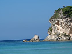
 Playa Macao in La Altagracia province, Dominican Republic | |
 Location of the La Altagracia Province | |
| Country | |
| Province since | 1944 |
| Government | |
| • Type | Subdivisions |
| • Body | 2 municipalities 5 municipal districts |
| • Congresspersons | 1 Senator 4 Deputies |
| Area | |
| • Total | 3,010.34 km2 (1,162.30 sq mi) |
| Population (2014) | |
| • Total | 372,289 |
| • Density | 120/km2 (320/sq mi) |
| Time zone | UTC-4 (EST) |
| Area code | 1-809 1-829 1-849 |
| ISO 3166-2 | DO-11 |
| Postal Code | 23000 |
Location
changeTo the north and east of the province is the coast of the Atlantic Ocean and to the south is the Caribbean Sea, with the Mona Passage (a strait that connects the Atlantic Ocean with the Caribbean Sea) to the southeast. The province is bordered to the west by La Romana and El Seibo provinces.
History
changeThe region of the province was part of the El Seibo until 1944 when it was made part of the new province of La Romana. In 27 February 1961, the La Romana province was split in two provinces: La Romana and La Altagracia.
The province was created with the municipalities of Higüey and San Rafael del Yuma with the city of Salvaleón de Higüey as capital of the province. Las Lagunas de Nisibón was made a municipal district in 1982, La Otra Banda in 1987, Boca del Yuma in 2001, Bayahibe in 2002, and Verón Punta-Cana in 2006.[1]
Origin of name
changeThe province was named La Altagracia (High Grace) because the Basílica de Nuestra Señora de la Altagracia ("Our Lady of High Grace Basilica") is in the city of Higüey, capital city of the province.
Population
changeIn 2014 (last national census), there were 372,289 people living in the La Altagracia province, and 222,802 (59.8%) living in towns and cities. The population density was 124.2 persons/km².[2]
Its population represents 3.94% of the total population of the country and the province is ranked as the 9th (out of 31 plus the National District) more populated province.
As of 2016[update], the total estimated propulation of the province is 322,653 inhabitants.[3]
The largest city of the province is Higüey, its head municipality or capital, with a population (in 2014) of 168,501 inhabitants.[2]
Geography
changeThe La Altagracia province has a total area of 2,998.4 km2 (1,157.7 sq mi).[2] It has 6.2% of the area of the Dominican Republic and it is ranked as the second (out of 31 plus the National District) largest province.
The altitude of Salvaleón de Higüey, provincial capital, is 87 m (285 ft).[4]
The main protected area in the province is the Parque Nacional del Este ("Eastern National park").
Mountains
changeThere are some low mountains in the northern part of the province. Those mountains are part of the Cordillera Oriental ("Eastern mountain range"). Savannas are found everywhere in the province.
Rivers
changeThere are not many rivers in this province. The main river is the Yuma that flows from north to south, into the Caribbean Sea.
Climate
changeThe climate of the province is a tropical climate, hot most of the year.
Municipalities
changeThere are 2 municipalities and 5 municipal districts (M.D.) in the province.[1] The municipalities and its municipal districts (M.D.) are:
| Municipality (code) |
Municipal Districts (code) | Population (2010) |
Area (km2) |
Density | Altitude (m) |
|---|---|---|---|---|---|
| Higüey (110101) | 168,501 | 907.7 | 185.6 | 87 | |
| Las Lagunas de Nisibón (110102) | 9,831 | 315.2 | 31.2 | 41 | |
| La Otra Banda (110103) | 28,929 | 318.9 | 90.7 | 108 | |
| Verón Punta Cana (110104) | 43,982 | 475.3 | 92.5 | 17 | |
| Higüey (110100) | 251,243 | 2,017.3 | 124.5 | ||
| San Rafael del Yuma (110201) | 17,886 | 530.8 | 33.7 | 55 | |
| Boca de Yuma (110202) | 1,821 | 232.0 | 7.8 | 16 | |
| Bayahibe (110203) | 2,260 | 218.4 | 10.3 | 9 | |
| San Rafael del Yuma (110200)) | 21,967 | 981.2 | 22.4 | ||
| La Altagracia province (110000) | 273,210 | 2,998.4 | 91.1 | ||
Economy
changeThe most important economic activities in the province are farming (cattle and sugar cane) and tourism. The eastern coast of the province, in the region of Punta Cana and Bávaro, is the most important touristic centre of the country with many hotels along beaches with white sand. Bayahibe, in the southern coast, is also an important touristic centre.
Related pages
changeReferences
change- ↑ 1.0 1.1 "División Territorial 2015" (in Spanish). Oficina Nacional de Estadística (ONE). October 2015. Archived from the original (PDF) on 14 November 2015. Retrieved 31 October 2016.
- ↑ 2.0 2.1 2.2 Consejo Nacional de Población y Familia. "Estamaciones y Proyecciones de la Población Dominicana por Regiones, Provincias, Municipios y Distritos Municipales, 2014" (PDF) (in Spanish). Retrieved 2014-02-02.
- ↑ "REPÚBLICA DOMINICANA: Población por año calendario, según sexo y grupos quinquenales de edad, 2015-2020" (in Spanish). Oficina Nacional de Estadística (ONE). Archived from the original (XLS) on 24 June 2016. Retrieved 31 October 2016.
- ↑ "Salvaleón de Higüey". Geonames.org. Retrieved 31 October 2016.
