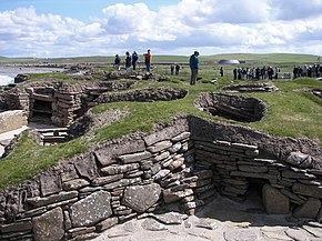
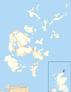
Skara Brae (pronounced /ˈskɑrə ˈbreɪ/) is a large stone-built Neolithic settlement on the Bay of Skaill on the west coast of mainland Orkney, Scotland. It consists of ten houses.
 Skara Brae, looking north | |
| Location | Mainland, Orkney, Scotland, UK |
|---|---|
| Coordinates | 59°02′55″N 3°20′35″W / 59.048611°N 3.343056°W |
| Type | Neolithic settlement |
| History | |
| Periods | Neolithic |
| Site notes | |
| Ownership | Historic Scotland |
| Public access | Yes |
| Type | Cultural |
| Criteria | i, ii, iii, iv |
| Designated | 1999 (23rd session) |
| Part of | Heart of Neolithic Orkney |
| Reference no. | 514 |
| State Party | Scotland |
| Region | Europe and North America |
It was occupied from roughly 3100–2500BC.[1] It is Europe's most complete Neolithic village. The level of preservation is such that it is a main part of the UNESCO World Heritage Site of the Heart of Neolithic Orkney. This is one of four UNESCO World Heritage Sites in Scotland, the others being the Old Town and New Town of Edinburgh; New Lanark in South Lanarkshire; and St Kilda in the Western Isles.
Discovery and features
changeUntil 1850, Skara Brae lay under years of soil sediment when in the winter of that year a large storm stripped the grass from the large mound known as Skerrabra.[2]
The outline of several of stone buildings was revealed and initial excavations were undertaken by William Watt, the laird of Skaill. It was fully excavated between 1928 and 1930 by Vere Gordon Childe following another storm in 1926.
Related pages
change- Heart of Neolithic Orkney
- St Kilda
- Edinburgh Old & New towns
- New Lanark
- The Antonine Wall is the most northerly part of the Frontiers of the Roman Empire World Heritage Site, shared with England (Hadrian's Wall) and Germany (Limes Germanicus).
References
change- ↑ Childe, V. Gordon & D.V. Clarke 1983. Skara Brae. Edinburgh: Her Majesty's Stationery Office. ISBN 0-11491755-8.
- ↑ "Visit Scotland". Skara Brae Prehistoric Village. Retrieved 2016-06-29.
Other websites
change- Historic Scotland Official Website Archived 2008-02-19 at the Wayback Machine
- Orkneyjar Archived 2009-08-03 at the Wayback Machine
59°02′55″N 3°20′35″W / 59.04861°N 3.34306°W
